I'll let Michael tell the story of this outing:
It all started late Saturday afternoon while Bill and I were snowshoeing
in the Sierras at the Carson Pass near Kirkwood Ski Resort. The snowshoeing
started out great and it went well most of the day until disaster struck.
We were on our way back at nearly 9,000 feet in a very remote area
about 1.5 miles from the parking lot on Route 88 at Carson Pass. Bill
started having shortness of breath, chest tightness and pain, nausea and
he felt extremely weak. He couldn't walk 10 feet without enormous
effort. We stopped to rest hoping it was just altitude sickness but
he did not improve after 45 minutes. We were worried about darkness
approaching and at 3:40 p.m. we agreed I had to go for help. His
dog Raleigh went with me. Raleigh was a real trooper during this
whole ordeal and it was very poignant to see how worried he was when Bill
vomited. He definitely knew something was wrong. I was following
our snow tracks back but it had been a warm, sunny day and they had melted
in many spots and I managed to get lost. I'll be honest and tell
you I was more than a little worried at that point because I knew time
was not on our side. Bill had been the guide (as usual) but we didn't
have maps because we had changed our route because the planned route did
not have much snow. It took me more than an hour to get back to Route
88. But I came out of the woods 2 miles away from the lot which actually
worked out better because I was closer to a store where there was cell
reception. I flagged down a car and got a ride almost immediately
from a nice, young couple with a dog. Unfortunately, in the excitement
of loading Raleigh into a small car with another dog in it, I left my snowshoes
and poles behind (a small loss). I called 911 and soon after the
fire and sheriff personnel arrived. They were planning to hike in
to locate him and then call a helicopter to take him out. I
convinced them to let me go with the helicopter to find him and save time.
They were reluctant due to safety rules and previous times when people
were unsuccessful.
I rode with the emergency helicopter
and we located Bill (not an easy task without a map and 1,000 feet above
ground) within 10 minutes of takeoff. And Bill, being the savvy out-doorsman
he is , helped enormously by reflecting a mirror when he heard the helicopter.
We landed and 2 great looking nurses named Kelly and Jenny gave him
emergency treatment (nitroglycerin spray, oxygen and IV fluids). We
loaded him onto the helicopter (Bill, it's time to lose some weight) within
2.5 hours from when I left him. It turns out Bill had a heart attack,
not a major attack (but then again that's easy for me to say). In
fact he did not think it was an MI when it occurred but he had 2 stents
implanted Saturday night.
I don't have too much to add. I never felt I was in any danger, aside from danger of staying the night out in the cold.
I'm doing well now (upcoming posts will reveal that I'm back out on the trails). Mostly coming to grips with the fact that I maybe can't wander wherever I want in the mountains by myself. That's a bummer.
Hike totals: 4 mi, 1500' elevation gain
2007 totals: 149 miles, 32, 800' elevation gain
Saturday, July 7, 2007
Apr 26 - Fremont Older North

Saw this coyote under the tree on the right just before the Hayfield Tr reaches turns to climb up to where it meets the Toyon Tr.
Our objective today was the northern edge of Fremont Older. When you reach the Coyote Ridge Tr., hang a right and go all the way to the end. When you reach the power line, there will be a turnoff on a trail down to Stevens Creek County Park. We went to this junction and turned around because it was getting dark. There's a little descent starting here and to go further would require climbing back up.
Hike totals: 3 mi, 400' elevation gain
2007 totals: 145 miles, 31,300' elevation gain
Apr 25 - Fremont Older Once Again

Lots of deer in the usual place.
Not much detail to add here. It was midweek (I was mulling my decision to quit AOL so skipping out early to use up my vacation days). On this one, I think we went up the Hayfield Tr, left on the Toyon Trail, then Bay View Tr. to Coyote Ridge Tr. after a climb to the top of the little hill off to the right.
Just a short jaunt.
Hike totals: 2mi, 400' elevation gain
2007 totals: 142 miles, 30,700' elevation gain
Apr 15 - Coyote Hills
Coyote Hills Regional Preserve
Details forthcoming...
Hike totals: 2 mi, 400' elevation gain
2007 totals: 140 mi, 30,300' elevation gain
Details forthcoming...
Hike totals: 2 mi, 400' elevation gain
2007 totals: 140 mi, 30,300' elevation gain
Apr 12 - Return to Almaden Quicksilver
Still out of the office, Raleigh and I headed to Almaden Quicksilver for a serious hike.
WAIST Management had been there on April 1st.
We basically went down the New Almaden Tr to some convenient point at which we climbed to the Randol Trail, the further on to the junction with the Mine Hill Road. We took that all the way back, descending almost to the parking lot off Almaden Rd.
That left a fair climb back along the Hacienda Trail., then to the car via the Virl Norton Trail.
I really pushed myself; around 12 miles in 4 hours, Plus some climbing. Saw a few deer along the way. Beautiful weather. Probably only one or two fellow hikers.
Beats working.
Hike totals: 12mi, 1700 gain
2007 totals: 138 miles, 29,900' elevation gain
Sunday, June 24, 2007
Apr 10 - Out of the Office at Fremont Older
I had a bit of a falling-out with new management at work late the week before so I took off the whole week April 9 - 13. On Tue evening I went out to Fremont Older to get in some miles with Raleigh.
We went up the normal route: Creekside Trail to Cora Older Tr to Hayfield Trail. We took that up to the Coyote Ridge Tr (top of the highest ridge there). At this point, we turned right. I wanted to explore the trails that head this direction (north) because I had never been there before. It was getting dark, though so we hurried to almost the point where one trail turns off to the left to descend to the Stevens Creek County Park. This was just pass a big green water tank.
We hit the turnaround time and immediately reversed course. It was almost dark by the time we got back. The lights in the valley below were beginning to glow.
Oh, almost forgot: it was my Birthday; the big 4-8.


Hike totals: 3 mi, 600' elev gain
2007 totals: 126 miles, 28,200' elevation gain
We went up the normal route: Creekside Trail to Cora Older Tr to Hayfield Trail. We took that up to the Coyote Ridge Tr (top of the highest ridge there). At this point, we turned right. I wanted to explore the trails that head this direction (north) because I had never been there before. It was getting dark, though so we hurried to almost the point where one trail turns off to the left to descend to the Stevens Creek County Park. This was just pass a big green water tank.
We hit the turnaround time and immediately reversed course. It was almost dark by the time we got back. The lights in the valley below were beginning to glow.
Oh, almost forgot: it was my Birthday; the big 4-8.
Hike totals: 3 mi, 600' elev gain
2007 totals: 126 miles, 28,200' elevation gain
Apr 08 - Pleasanton Ridge Pleasantry
The family (Malinda and Allison) were off to Boston this morning to visit colleges.
Michael, Raleigh and I headed to Pleasanton Ridge Open Space Preserve (East Bay MUD).
This park was of interest mainly because dogs are allowed. It's also close enough to warrant a visit on a Sunday afternoon.
We climbed the hill by way of the Woodland trail. It has nice switchbacks and is way more appealing than the fire road. Once we reached the top of the ridge, we took the Ridgeline trail north all the way into some Pleasanton city park then connected to the Thermalito Trail to return along the other side of the ridge.
We descended the Oak Tree trail [sic], really just a bad fire road.
This is a pretty nice park. Beautiful at this time of year but probably hot in the summer. The trail goes through an interesting olive grove at one point. We saw numerous wild turkeys and I'm sure there are lots of deer (although I don't think we saw any).
Good views from the ridge from Mt. Diablo down to Mission Peak.
You can probably string out a good long hike here, too. We did 7 miles but could have continued along the ridge for 2 or 3 more, at least. There was water at a couple of points so it might not be that bad in summer; maybe I'll return.
Hike totals: 7 mi, 1500' elev gain
2007 totals: 123 miles, 27,600' elev gain
Apr 07 - Arastradero Preserve
On this Saturday, I was luck enough to be accompanied by my wife, Malinda. She had given me a set of coupons good for day hikes on Valentines Day and this was the first chance I had to redeem one.
We took Raleigh to Arastradero Preserve for a short walk. It was kind of a cool blustery spring day, as I recall (cloudy, by the looks of the picture). Did an uneventful walk up the hill and back. We spotted this banana slug in the road on the way back.
We also saw a deer in the same vicinity. As we approached the road on the return, Malinda spotted a coyote across the trail.
Afterwards, we went and picked up dinner at the Green Elephant in Palo Alto (Middlefield at Charleston). It's more distinctive than the typical Asian restaurant (Burmese, I think); I recommend it.
Hike totals: 3 miles, 200' el gain
2007 totals: 116 mi, 26,100' elev gain
Wednesday, April 4, 2007
April Foolery at Almaden Quicksilver - Sun Apr 1
April Fools Day arrived and coincidentally was the re-scheduled date for the April W.A.I.S.T. Management hike at Almaden Quicksilver County Park.
We had a great turnout: me, Alberto (the leader; great job), Sarah, Michael, Jay, Anne, Maura, Barbara, Ed, and Linda (a special occasion to have her join us). 11 if you count Raleigh.
It was a modest hike. We went up the Virl O. Norton Trail, wandered along the Randol Trail (with some detours) and then down the Buena Vista Trail to the New Almaden Trail which by which we returned to the parking lot.
The biggest detour was to climb up the Day Tunnel Trail only to find there wasn't anything of interest at the top. So we turned around and retraced our steps on that one. We were looking for the old mine shaft entrance where you can walk a ways into the tunnel. That must be one of the other marked mine sites we didn't get to (San Cristobal, Santa Isabel, or April tunnels).
On the first major downhill after leaving the parking lot we found a group of bicyclists in the trail. One women was sitting with her head kind of between her knees. We asked if we could help but they said no. A few minutes later, a fire truck drove up and administered first aid of some sort. I'm not sure how that turned out.
We stopped for lunch at the Buena Vista mine site.
On the way back, Maura slipped on the wet rocks crossing Randol Creek. She used her left arm to break her fall, and unfortunately, broke her wrist. Ouch. But she was amazing. Jumped back up, refused to stop, and continued on to the end of the hike. I was kind of worried we might have to summon that fire truck to come back, but that wasn't necessary.
We enjoyed a beer in the nice picnic area (although Maura declined in order to get to the hospital to get her arm fixed). Thanks to Michael for that.
The hike was claimed to be around 4 miles but I added up the official length of all the trail segments and it came to over 5 miles. I'm guessing 600' elevation gain (the top of the Day Tunnel trail is at 1200' according to the map). Not too bad.
Next month is Bay to Breakers. Remember we're doing the naked centipede thing again this year! (April Fools!).
But Barbara hinted at some kind of surprise extra-curricular hike the first weekend of the month. Stay posted for that.
Hike totals: 5 miles,600' elevation gain
2007 totals: 113 miles, 25,900' elevation gain
Moon Over Mt. Eden - Sat Mar 31
On Saturday I took a break from various projects around the house to do a quick hike at the Mt. Eden trailhead at Stevens Creek County Park.
Raleigh and I went left at the start of the trail, down along the edge of the neighborhood there to the small corral (with 3 horses and 1 pig, as I noted in a previous post). I had my altimeter and took careful measurements to see how much climbing this trip involved.
You go up maybe 25 feet from the parking lot, then descend to a little dry creekbed close to the road, then climb up another 25' or so to the washed out section of trail, then descend to the corral. That's at 725' (according to my altimeter). From there it is uphill the whole way to the end of the trail at the vineyard.

As you can see, it was getting dark. That spot was at 1375' give or take. So 650' climb from the bottom. Add the little uphills along the way and it's a 700' gain for this loop. Obviously, it is way more if you take the loop in the opposite direction :-).
Nothing much to note along the way. It's just nice to be able to get out and away from civilization within a 15 minute drive from one's house.

Hike total: 2 miles, 700' elevation gain
2007 totals: 108 miles, 25,300' elevation gain
Monday, March 26, 2007
Sticking it to The Man at Fremont Older - Fri Mar 23
Took another Friday afternoon (evening, actually) walk with Raleigh up to Fremont Older. We had a beer bash at work so I could get out reasonably early again. I remember now that the week before Kai let us out early (he was heading out on vacation and was feeling generous, I suppose).
We did just about the same hike we had done Wed morning. Well, not quite. I headed up the hillside (cross country) from the bend in the road near the Creekside trail (following a firebreak, so it isn't like I'm trodding on untouched soil or anything). At the top, Raleigh picked up the scent of something and we went across the grassy hillside across the Haystack trail (fire road). There was a coyote sitting in the grass there. They sometimes give Raleigh fits because he doesn't quite know what to make of them. They look like dogs, but probably don't smell like normal dogs. And they aren't with any people.
Anyway, we headed back over to the road. A passing bicyclist remarked that the ranger was parked on the road up by Hunter's Point and he might write me a ticket for going off-trail.
Imagine that! I told the bicyclist that they'd have to drag me kicking and screaming out of my land (or my portion of the public's land; my portion being that part which is well off the trail). Actually, I checked the sign on the way out and it said that bicyclists and equestrians must remain on designated trails. Which means, to me, that us folks on foot can go wherever the hell we please (even if it does mean regretting it a week later when the poison oak is at its worst).
Well, I headed towards the ranger but before getting there, I turned off on a short spur road, went cross country (take that!) up to Hunters Point, then down and around, returning back by the road and Creekside trail.
Arrived back at the car at sunset minus 30 seconds. We're getting pretty good at that.
I've been studying the map and am planning a "Compleat Fremont Older" expedition which will have us covering every inch of trail in one outing (plus maybe Parker Ranch Trail to boot). There are a maze of trail in this park! Could require lots of advance planning to make sure we don't miss any. Could be a good candidate for a moonlight, covert operation (as this park definitely closes after dark).
I do believe one could park at the foot of Parker Ranch Trail withnodifficulty, however...watch for an update soon. Full moon is on April 2.
Hike totals: 2 miles, 200' elevation gain
2007 totals: 106 miles, 24,600' elevation gain

Good Morning Silicon Valley - Wed Mar 21
I took Raleigh out for a morning walk to Fremont Older on Wednesday.
We rarely get out in the morning, even on weekends.
It turned out to be a much better time to visit Fremont Older. Seems everybody else was going to work or something.
Plenty of free parking. Went up the Cora Older trail (which I usually avoid due to crowds). Looped around Hunter Point and returned via Creekside Trail. It was another beautiful spring day (that string of good weather ended today; I'm looking out the window at the rain right now).
It was kind of nice to look out on the valley in the morning light. I think retirement might not be so bad...
Hike totals: 2 mi, 200' elevation gain
2007 totals: 104 miles, 24,400' elevation gain
Mt Eden Loop - Sun Mar 18
Sunday evening rolled around and I felt compelled to go out once again (third time on this weekend).
Took the short drive to Mt. Eden trailhead and took the "normal" route: up the main "trail", then up the ridgeline to the upper road, up that to the deadend at the vineyards, then back down the backside (following the private horse trails which they graciously open to public passage - thank you kind landowners).
Nothing of note to report, though. It was late so we hustled down, then back up to the car (which is a bit disheartening) to finish before dark. Only saw one other person: a homeless-looking kind of guy laying in the sun at the top of one of the switchbacks. He would have kept me there till dark listening to his tales (about dogs) if I had let him. Which I didn't :-).
Hike totals: 2 miles, 500' elevation gain
2007 totals: 102 miles, 24,200' elevation gain
Harver Bear Ranch Outlaws - Sat Mar 17
For some reason, I got it in my head that the new Harvey Bear Ranch county park (Santa Clara County) allowed dogs. I don't know why. But I planned a trip there, went (with Raleigh), and returned. It wasn't till afterward that I noticed (researching another hike) that this park actually doesn't allow dogs on the trails.
Oops.
No matter. We only saw 2 other people (but we did run into them twice during the afternoon). Otherwise, we had the park to ourselves (aside from a couple people with horses and one guy with a llama in the parking lot).
The bottom line: I think they only care about the dogs in parks where there are people or if the dogs cause a problem. Kind of like smoking pot, I suppose.
It continued to be a gorgeous spring weekend. Warm and sunny with lots of poppies blooming. I have lots of pictures which I'll upload later.
The hiking there is mediocre. The lower reaches of the park are open and I'm sure very hot in the summer. The ridge up at the top, above Coyote Lake, is nice walking with lots of oaks and gradual ups and downs. This would be a nice up and back hike from Coyote Lake parking (thus avoiding some of the exposed, lower western-facing slopes and much of th climbing).
After we got to the top of the ridge, I decided to climb to the highpoint at the northern end of the park (there's a similar hill at the other end which we didn't get to). At the top are piled a bunch of large rocks, which I had to scramble on to get to the highest point (which I just had to do :-).
Jumping down off the rocks, I heard what I immediately thought must be a rattlesnake! It rattled and rattled and rattled for what seemed like minutes. I stood still looking for it. I wanted to take a picture and it didn't sound close enough to strike. I never did figure out where it was. As I retreated, it did another long rattle.
So I call that hill Rattlesnake Hill.
We headed south until it was time to head back. Given more time, it would be nice to hike that whole ridge which would make about 8 miles or so up and back. We doubled back a ways and headed downhill. We had to chase some cows out of our path. Got back to the car at sunset, exactly (as usual).
This hike puts me at the 100 mile mark for 2007!
Hike totals: 9 miles, 1500' elevation gain
2007 totals: 100 miles, 23,700' elevation gain
Spring has Sprung at Fremont Older - Fri Mar 16
Took off from work early on this Friday (I don't remember why; mostly fed up with crap going on there, probably :-).
I decided to head up to Fremont Older with Raleigh. I don't usually get out on weekdays. The first problem was that they were working on the railroad crossing at Prospect Rd. I had to find the detour through the Seven Springs subdivision. That wasted precious moments before sunset.
Then, the parking lot was still crowded. Bad enough to find it that way on a weekday. But with the main road blocked? Sheesh.
We did get a spot and headed up the road. Took the creekside trail cutoff, as usual, then got to the fire road through the grassy hillsides. Poppies everywhere. It was sunny and warm. The grass was green. Raleigh had a great time eating it.
It was already getting late so we just went up to the Hayfield Tr turned left, went a ways, then cut back down to the fire road leading back to the Creekside Tr. Saw a few deer on the hillside above the trail where they usually assemble. Nothing else of note.
But a nice outing to close out the work week.
Hike totals: 2 mi, 200' elevation gain
2007 totals: 91 miles, 22200' elevation gain
Off Trail at Mt. Eden - Sat Mar 10
A week later I went out for a short jaunt at Mt Eden Trail (part of Stevens Canyon County Park, I think). There is a parking area at the top of Mt. Eden Rd in Saratoga. There's one trail which connects with some private horse-riding trails on the back side.
This time I went up the normal road then started down at the second "junction" towards Stevens Creek. You can go all the way to the creek if you cross Stevens Canyon Rd at the end.
I was with Raleigh but we stopped just short of the road. It's a bit of a scramble down to the road for no good purpose except to let Raleigh get a drink, but that wasn't necessary today since we were just out for a short walk and it was pretty cool (and late).
On the way back we scrambled up the wooded slope to the right of the road down near the bottom. The hill isn't too steep there and the understory not at all brusy (i.e., no poison oak threat).
We followed a gradual creekbed up, then contoured up to the top of the ridge back towards Stevens Creek. We then followed the ridge up until the way started to get brush-filled again. We picked up a good use trail that went back towards the south and headed down when we reached the creekbed we had started up. We were much higher at this point and it took a while to get back to the road where we had left it.
By then it was getting kind of dark. We returned the same way we came, ending up at the car at sunset, more or less. Fifteen minutes later we were back home.
I'm thinking we'll head up this way again someday and try to follow that ridge up higher to see what's up there. Probably end up in somebody's backyard; maybe one of the vineyards that are up at the top of the normal trail there at Mt. Eden.
Hike: ~2 miles, ~1000 elevation gain
2007 Totals: 89 miles, 22,000' elevation gain
My Mission Peak Mission - Sat Mar 3
Sat Mar 03
Its been a while since I posted. But not since I've been out on the trails. I've got 7 trips of various lengths to report on (some are even interesting).
Starting with this one...
...the March W.A.I.S.T. Management hike was way back on Mar 3rd. After some wrangling over destination for the March hike, many of us ended up at Mission Pk to climb by moonlight (it was a full moon that night).
Participants: me, Steve, Michael, Jay, Ed, Barbara, Alberto, and Sarah. Barbara dropped out after a mile or so. Too much climbing and distance for her. Us young -uns (I jest, Barbara's birthday is one day before mine, or something like that :-) didn't know any better, apparently.
I was out to complete my long anticipated "triple:" climbing all three of Mission Peak, Mt. Allison, and Monument Peak, the 3 highest points on the ridge above Milpitas and Fremont just south of the Sunol "pass" (do they call that a pass? It's definitely the "Sunol grade" when you're climbing it on 680).
See my previous exploits in the same area twice in the previous months, recorded in previous entries to this humble journal. I remarked in the last one that it would have been nice to have climbed Mission Peak as well on that trip. So I had resolved to give it another go.
The mission was ambitious. Plus, it was by moonlight. The parking lot is posted as being open till 10pm. I notice that the park web site says till dusk, however. So go after sunset at your own risk.
The hike was pretty uneventful. We only got lost once. Well, Ok; maybe twice. But we weren't really lost. I missed the turn towards Monument Peak coming down from Mt. Allison (due to poor lighting and distractions shooting the breeze with other hikers). We had to go cross country a couple of hundred yards to pick up the road heading over to Monument Peak. No biggee.
Coming back, I erred and led us downhill on the road to Mt. Allison. That was just a brain fart. I thought the road junction there was a different junction and insisted on turning, even though it was at the wrong place. This one took us downhill a couple hundred feet. Eventually, I went around the ridge to the left to get a view of Mission Peak. After some scrambling up to the top of a rocky hill, above a steep rocky canyon to the NW, I called out for everybody to turn around and rejoin me up at the top.
Things were uneventful from that point on. We got to the top of Mission Peak just before 9pm. Wanting to avoid a ticket for being parked in the lot past closing, I jogged pretty much all the way down (3 miles) with Steve. We got there after about 45 minutes to meet Barbara and then wait for everybody else.
We did enjoy a cold beer while waiting (that's probably illegal, too). Sarah and Alberto were the last to arrive. We spoke to Anne by phone in order to cancel the next days outing (what would have been the real WM hike). She gets full credit for christening this the "Mission Peak Mission."
Mission Accomplished!
Hike totals: 9 mi, 3000' elevation gain
2007 totals: 87 miles, 21,000' elevation gain
Saturday, February 24, 2007
The (Almost) Compleat Uvas Canyon - Mon Feb 19
Monday was a holiday for me. I called Michael to see if he wanted to tag along, but he had to work. Too bad for him.
Inspired by my efforts at Fremont Older on the previous Saturday, I decided on a somewhat ambitious plan to hike every inch of trail at Uvas Canyon County Park. I sketched it out on the map and it looked to be about 12 miles. Only one serious uphill, but that would prove to be the obstacle that prevented me from completing the task.
We (me and Raleigh, as usual) got to the park slightly after noon. The entrance fee machine was out of order. All I had was a $20 bill and I didn't want the county to make too much profit (the fee is $5; I mailed it in today). So I filled out the receipt and stuck it to my window, hoping they wouldn't detect that there was no money in the drop box. I don't think they did.
The first problem was finding a parking spot. I wanted to park at the start of the Knib's Knob trail but the group camping area was gated off and there was nowhere to park in the camping area further along. So I had to double back and park at what I thought was the beginning of the Alec Canyon trail. The nice signboard had a "You Are Here" sign, pointing to someplace else. In otherwords, it should have said "You Are Not Here." I walked back up the road towards the entrance gate until I figured out that the sign was full of crap.
After a little ways, the Alec Canyon Trail switchbacks up a few hundred feet and tops the ridget at Manzanita Point. Views across Uvas Canyon predominate; eventually you can see east back down into the Santa Clara valley.
After Manzanita Point the trail drops down some then you climb a little up Alec Creek's canyon until the trail ends in the vicinity of some kind of logging camp (according to the map and signs. We doubled back and on the return went up a short trail to Triple Falls. It's a typical Santa Cruz mountains waterfall. More of a really steep rapids; but worth the walk.
Back to the trail, up the Manzanita point again, then we turned on the Contour Trail junction which is .5 miles from the start. This is a great trail, matching its name. It rises very gradually from about 1600' to 1800' over a course of 1.5 miles or so. Nice woods the whole way.
When this trail reached Swanson Creek, we weren't sure where to go. There were use trails upwhich we tried; those fizzled out. Normally, you expect the trail to cross the creek when you reach it. But here, the trail descended the same side of the creek for a couple hundred yards, then crossed it. We saw a couple scrambling further down the bank; I thought maybe they had got waylaid at the same point coming up.
Just past here is marked the "Hothouse Site." We went a little ways up on a use trail and saw a maze of pipes across the ground and pieces of broken glass. I guess there used to be a greenhouse here.
A short ways further down is the main waterfall basin. The waterfall loop trail/road lead here, and other trails branch off to Knobcone Point, Black Rock Falls, and another small waterfall (maybe Basin Falls?). I went up all those trails. The Knobcone Pt trail is steep, .4 miles and totally lame. At the top is a buldozed clearing with a picnic table. No views.
Black Rock Falls is nice; most picturesque of the whole lot, I'd say.
In order to cover all the trails, I had to descend the Waterfall Loop Trail a little ways, then come back up the Waterfall Loop Road. I then doubled back and descended the trail .3 miles to where it met the road again. I then climbed back up the road and immediately turned around and doubled back.
Just before the road met up with the Alec Canyon trail where we started, it intersects the Swanson Creek Trail. There's a little triangle and I had to go around in a bit of a circle to cover all of the trails. Finally we made our way down the Swanson Creek Trail to an "access" trail which led to the upper area of the park for the trail to Knib's Knob.
It was 4:15. I wanted to be back to the car by 5:30 because they said they locked the gate at sunset (which was just before 6:00). From the Knib's Knob trailhead to the summit is something like 2.5 miles (not counting the .2 mile turnoff to the knob itself).
I knew I wouldn't make it, but I decided to climb up to the bench on top of the ridge. That was about 700' up and .4 miles or so. After 30 minutes of steep climbing we were there. Then booked down in 15 minutes.
Aside from the upper reaches of that trail, the only bit left was the Uvas Canyon trail to its junction with Swanson Creek and then the stretch of Swanson Creek trail back to the road where we had left it earlier.
The walk along the creeks wasnice. At the junction was a narrow, very steep, rocky descent that Raleigh wasn't able to negotiate (or so I thought; he tends to get too much momentum and I was afraid he'd go right off the edge). So instead we descended to Uvas Creek and walked up the creek, crossing and re-crossing, then hopped across Swanson Creek.
A quarter of a mile up the creek got us back to the road. We ascended the trail a bit further (along a stretch we had already done), then turned onto the Waterfall Loop road to complete the last hundred yards until it met Alec Canyon Trail.
That was at a point just beyond the parking lot. We arrived back at the car at 5:00.
The ride back along Uvas and McKee roads was nice. Scenic green hills this time of year. A big turkey ran across the road right in front of us at one point. Wild turkeys are supposed to be smart but I think they're pretty clueless. One time Raleigh and I walked right up to one that was so busy pecking at bugs or seeds that it didn't even see us till we were right on top of it.
The turkey in the road survived.
Hike totals: 10 miles, 2300' elevation gain.
2007 Totals: 76 miles; 17,200' elevation gain
Mt. Eden Loop - Sat Feb 24
Despite the drizzly weather, Malinda chased me and Raleigh out of the house for a short hike this afternoon. We went to Mt. Eden Open Space Preserve. Actually, I'm not really sure if it's a preserve in its own right or just part of Stevens Creek County Park or something.
Regardless, we parked at the top of the "pass" between the Mt. Eden "valley" (Saratoga foothills) and Stevens Canyon and started off downhill (to the left) from the parking lot.
Not many people hike here, and fewer go that way. We followed the road (through a couple of real muddy spots). Just past the deep gully/washout, we tried to go up a use trail through the chaparral. It was steep going and the route fizzled out before meeting up with the horse trail up above. So we doubled back to the trail.
Soon enough, you come to a small muddy corral. There were a couple small horses and a pig (!) in it; they got a little agitated seeing Raleigh. The road then goes up steeply through the oaks via a few switchbacks. Views of the Saratoga hills appear, then further out into the valley to San Jose and beyond.
The trail/road is kind of nice. It's mostly covered with wood chips so it doesn't get muddy.
After you pass under the power lines, you're back into the preserve (prior to that you pass through private property marked with "permission to pass granted" signs). The road is a gradual uphill till it ends at a vineyard (there's another vineyard if you take the road that branches off to the right at the top).
Nothing too interesting along the way. We descended the standard route back to the parking lot.
Hike totals: 2 miles; 800' elevation gain
2007 totals: 78 miles; 18,000' elevation gain
Sunday, February 18, 2007
Wandering around Fremont Older
After a weekend lost to rain, Raleigh and I went back out yesterday, Sat Feb 17. We went to Fremont Older preserve and wandered around until it got dark.
First, I decided to not even try to get a parking spot in the main lot. Having discovered the Parker Ranch road (see entry from last month), I figured I'd park somewhere along that trail and hike into Fremont Older from there. I picked a spot on a cul-de-sac right next to a trail sign and set out.
This route goes through a bit of meadow and woods, then along a road that goes to a large green water tank. The trail goes up the ridge from there to Fremont Older's extreme southern edge.
This is where the wandering started. We took the Toyon Trail to the last intersection before it ends at the Hayfield Trail. Veered left onto the Bay View Trail to the Coyote Ridge Trail. Went right on that a short ways and climbed the little peak off the trail on the right. Doubled back then went right on the Fern Trail. Took that to the Vista Loop Trail. Went right until it hit the Coyote Ridge Trail again, went left. Climbed Maisie's Peak. Continued a short ways beyond and then turned right on the Bay View Trail again (reverse direction from before). Took the Bay View Trail to its end back to the edge of the preserve where we headed back down the Parker Ranch Trail.
No wildlife sightings of note (lots of rabbits, though). A covey of quail exploded out of a tree along the side of the road and gave me a bit of a scare. No deer! There was a sign about a crazed coyote on the loose; maybe it was chasing off the deer, too.
Hike totals: 8 miles, 1000' elevation gain
2007 totals: 66 miles, 14,900' elevation gain
Super Stroll Sunday
Come Super Bowl Sunday, I quickly recovered from the WM hike at Pt. Reyes the day before and decided to head back to Monument Peak. I had attempted to climb it a week earlier but sort of missed.
I figured everybody would be watching the game, but the parking lot was still full when I got there at 3:00 and I had to wait for somebody to leave. We set out up our usual route (the more interesting Peak Meadow Trail to Horse Heaven Trail).
This time, it was clear on the top of the ridge and I knew where to go. We turned right after passing through the fence that runs along the top between Mt. Allison and Mission Peak. This little road gets fainter and eventually turns into a use trail which goes up a gully right up to the top of Mt. Allison. It's kind of crowded up there with radio and tv towers, but one feels compelled to get to the highpoint regardless.
At this point I had to decide whether to push on to Monument Peak. It's something like a mile and half between the peaks so I was looking at one hour minimum to get there and back. It was 4:30 or so so I would likely be heading down in the dark. But I had my headlamp and thought the darkness couldn't be as bad as the clouds the week before so I set off for Monument Peak.
It was a nice ramble across the ridgetop. Great views down towards Sunol. Nobody else up there. I don't think many hikers head this way and it was too late for any sane ones.
The sun was setting when we reached the top of Monument Peak (just about the same height as Mt. Allison). Nice views all around. Then we headed back. We (oh, "we" is me and Raleigh) took the regular road back towards Mission Peak. On the way, we kind of went cross-country over Mt. Allison.
It was getting really dark as we went around Mt. Allison to the gate in the fence to start the real climb down. The lights below were pretty bright and the sky almost black.
Once we reached the gate, it was plain nighttime so I got out my headlamp. The next couple hundred feet of descent is cross-country here; I just kept heading down and bearing slightly right so I would eventually hit the Horse Heaven Trail, which we did soon enough. It was an uneventful descent from there. Didn't seem anybody on our route, but I could see lights on the main trail down from Mission Peak (bikes, I thought).
Next time, Iwant to do all three peaks in one trip. It would only have required another mile or so of walking and would have been easier coming down the trail from Mission Pk. I might try that on Mar 3 (when there's a full moon). I should try to find somebody willing to tag along.
Hike totals: 8 miles, 3000' elevation gain.
2007 totals: 58 miles, 13,900' elevation gain
Waist Not, Want Not
W.A.I.S.T. Management got the new year off and running (well, walking) on Sat Feb 3. Sorry I'm so tardy filing this report.
We hiked from the Palomarin Trailhead in Pt. Reyes National Seashore to Wildcat Camp (and the beach there), with stops along the way, Allamere Falls being the main one of note.
Hikers were: me, Michael, Jay, Anne, Maura, Gina, and Joan, plus David (who works with me) and his daughter.
It was quite the adventure. First, we were late to the trailhead. We spoke to Gina (who was with Joan in her car) and knew we had time to stop for coffee in Bolinas. So we missed David and his daughter whe eventually left without us. We met up with them later.
Gina and Joan didn't show for the longest time. They missed the turn off Highway 1 to Bolinas (the signs get removed by reclusiva Bolinasoids, apparently). We about missed it ourselves. They arrived after we were a few hundred yards up the trail so we turned around to go back for them.
Once underway, we had a great hike. Ran into David and his daughter a mile or so in. They had gone 2+ miles or so and were headed out. At least we got to say hello.
Smooth sailing all the way to the falls. Getting down to them is quite the adventure. Everybody got to the top of the last bluff before the final drop to the beach. Michael, Jay, and I scrambled down that last bit as well. We had lunch there.
We pressed on. Michael and Jay bolted, never to be seen again (almost, we did see them on the way back from Wildcat Camp). The rest of us followed the coast trail to Wildcamp Camp and down to the beach there. It was getting late (around 3:30) and we headed back (taking the Ocean Lake Loop).
We were getting pretty tired at this point, Joan moreso. The sun set as we headed back down the coast. We got out the headlamps the last mile or so, and arrived back at the car at 6:30 (it got dark around 6:00).
Stopped for dinner in Olema and drove back Sir Francis Drake Blvd. I got home in time for the 11:00 news. Long day, but nice hike.
There was some political unrest regarding that point. Some felt that we were scaring off potential hikers with such abuse. There was also some grumbling about the group splittin up into fast vs. slow factions. I think it was just the sore leg muscles talking.
We'll see how it goes this year.
Hike totals: 12 miles, 1500' elevation gain (maybe more, but it wasn't that much up and down).
2007 totals: 50 miles; 10,900' elevation gain
Sunday, January 28, 2007
Mission Peak, Accidentally (Sat Jan 27)
I have been wanting to climb Monument Pk again (I've done it a few times years ago). But everytime it had been a pretty unpleasant experience starting out at Ed Levin County Park. That trail sucks, it was always a hot day, etc.
I had also wanted to hike the stretch of trail (more like roads, actually) between Mission and Monument Peaks. While thinking about doing an afternoon hike this weekend, I got the idea to head up Mission Peak, bear right, and take the trail along the ridge to Monument Peak.
Off we (me and Raleigh) Sat afternoon. It had rained but looked to be clearing up. I wore my rain hat and took a windshirt. If the weather got nasty, I figured I'd just turn around.
We left the Stanford Ave. parking lot around 2:45 and immediate turned right onto the Peak Meadow trail (unsigned, I think). This trail crosses the creek and then heads uphill in a steep and steady climb. At 1100' you reach a creek crossing. Here I usually take the use trail straight up the hill. This is really steep, climbing 400+ feet in 1/4 mile. That took me 14 minutes (I timed it). I only stopped to catch my breath once (I also paused a couple of times to let a group of hikers coming down pass us).
One then follows the ridge (much less steeply now) to where you meet the Horse Heaven Trail. I don't think the map is very accurate about the placement of this trail. It seems to be routed much further to the east than shown; you kind of contour to the right and follow along a steep drainage which seems to be on the edge of the open space boundary below Mt. Allison.
Anyway, eventually you come to a horse trough here; there's a spring on this hillside and you can see a large section of the hillside slipping down below the watering hole. The trail kind of trends left (west) here and we went right, and up, following the creekbed (which at this point was just a dry gully). After a 1/4 mile or so, we came to the top of the ridge to the right of this gully and picked up a nice wide use trail which had the look of an abandoned road bed. Up we went on that for a while until it petered out, at which point we struck off straight up the hill, pretty much.
At this point we were south of the midpoint between Mt. Allison and Mission Peak. This is on the park boundary and there's a fence. The last time I was there (2 years ago) the fence was pretty dilapidated and you could step over/through it anywhere. But now there were 5 strands of new barbed wire securely strung along it. I could see a gate towards the east so we followed the fence line, stepped through the open gate, and across a faint roadway (double-track).
The last detail (the road) escaped my notice, which would help account for the confusion about our location that ensued. At any rate, I knew I had to contour around the other side of Mt. Allison so we headed cross country (level) towards the northeast. Eventually, we crossed a double-track but obvious roadway. Thinking this was the road between Monument and Mission Peaks, we went right on the roadway (which was a relief because the cross country was somewhat awkward due to cows leaving the hillside very uneven with their footprints in the soft turf).
Oh. I forgot to mention that as soon as we topped out at the top of the ridge, the wind (from the northeast) kicked up and we were completely enveloped in fog and clouds and mist. I put my jacket on. Visibility was maybe 100ft.
Anyway, at this junction one road went right and slightly uphill (at least the little bit I could see) and the other went left. These weren't right angles, of course; the route to the left was more in line with the road we were on. Thinking I was on the road heading away from Mission Peak, I figured the road to the right went up to Mt. Allison and the one to the left would curve around and lead to Monument Peak.
The road did curve around, but just for a brief stretch before it curved back towards the west and Mission Peak. But being completely enveloped in fog, I only had a vague feeling that I wasn't going in the right direction. And since I had just left the road from Mission Pk (or so I thought), surely this one would either go to Monument Pk or head downhill.
After a while I came to signposts marking the Eagle Loop trail and Peak Trails. That didn't sound right to me, but I kept pressing on. Eventually, I thought the trail looked familiar; kind of like the trail to the top of Mission Pk (from the east). Soon enough, we were on top, and saw the little signpost with "Mission Peak" spelled out with nails.
Needless to say, we didn't hang out there long. You couldn't see anything. And there was nobody else there, due to the weather and late hour, I presume. We returned the way we came (taking care to make the right turns to end up where we started). The cross country stretches were interesting since it was impossible to see where we were headed (unlike on the way up). But eventually we hit the Horse Heaven Trail at about 2000' elevation and from there ran down much of the way back to the car, arriving at 5:45 (around 1:15 for the return trip).
I've been thinking about "being lost" on this trip and have come to some conclusions:
- A map is useful, even if you don't think you'll need it. If the weather had been clear, then I would have know exactly where I was and where I was going. But with zero visibility, the map would at least have given me a chance to reconcile the trails with where they headed.
- This situation is where a compass is useful (I had a compass, just didn't think to take a reading and see I was headed north, then west, rather than south towards Monument Pk).
The interesting thing is that I can look back and see exactly why I thought I knew where I was headed. Here's the official map and our route (in blue). I've drawn in the fence line that we walked along and the unmapped road that we joined up with before making the wrong turn.
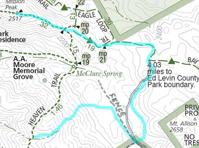
And here's what I thought was going on:

Again, I've drawn in the fenceline. In this second map, I've redrawn the roads/trails according to where I thought they were layed out. Basically, things were rotated 90 degrees or so from what I thought they were. It's easy to see my mistake in hindsight. But it's easy for me to look back and play over in my head what I was thinking at the time.
Bottom line: check your assumptions using a map and/or compass. My GPS would have done the trick, too (provided I had the foresight to record the waypoints for the peaks and/or trail junctions).
Lesson learned. It did make the trip more exciting. Nothing like not knowing where you are to spice things up.
Hike: 7 miles, 2300' elevation gain
2007 totals: 38 miles, 9400' elevation gain
Not bad for the first month. On a pace for 450 miles, so I should be to 200.7 around Memorial Day.
Tuesday, January 16, 2007
Pimkolam (Junipero Serra Peak) - Mon Jan 15
Ok; I need to write about this before I forget anything...
Abandoning a snowshoeing trip to the Sierra because it was really cold, I decided to instead head to the Ventanta Wilderness area down Monterey County way and climb "Pimkolam" (the native's name for it, which I tend to favor), aka "Junipero Serra Peak."
Some random notes:
Abandoning a snowshoeing trip to the Sierra because it was really cold, I decided to instead head to the Ventanta Wilderness area down Monterey County way and climb "Pimkolam" (the native's name for it, which I tend to favor), aka "Junipero Serra Peak."
Some random notes:
- The road to the trailhead is great! Nicely paved, not too many twists and turns. No traffic. It took me 2:40 driving time to get there, a few minutes more on the return.
- The trail is in danger of being overgrown with brush on the explosed slopes and in the manzanita forest, in places. The Ventana Wilderness Alliance clears it now and again, thank goodness. Not much poison oak (the trail is wider where that grows).
- Little or no water along the way. I carried 3 liters for me and Raleigh and there was one stream crossing where Raleigh drank.
- The trail is a pretty nice steady grade, all in all. Unrelenting, though. It reminded me a bit of the climb up Mt. St. Helena in terms of distance and climb. The terrain was very similar to Wildrose Peak (in Death Valley), although not quite as steep a climb as that one.
- It took me 4 hours to go up, 2 hours down. I kind of bonked the last half mile on the way up. I needed something to eat, but I didn't want to stop before reaching the summit.
- Saw one guy (military, he was studying Korean at the language school in Monterey) at the top. Two guys heading up while I was on my way down. Once was carrying a full pack but said he was just training. The other guy was carrying nothing. I told them it was still 1000' to the top (this was at 2:45) and I had doubts they could make the top and return before dark. But off they went.
- A couple other cars in the lot (I saw two people on the sandstone cliffs near the trailhead).
- The ocean was a bit hard to discern. There seemed to be a cloud bank over it. It did reflect the sunlight pretty brightly, but that might have been off the top of the fog, too.
- The Sierra (I think) was barely visible in one gap towards the east. I had to use my monocular to see it, and it might have been a band of clouds. I'll have to go back on a clearer day (although it wasn't too bad). I need to visit other areas so I know what I'm looking at.
- I took my real camera but the battery (freshly charged, I thought) was dead. So all the pictures are from my phone. Not too bad; I'm pretty happy with it as a backup camera.
I felt great; I had some concerns about such a major effort but I made great time until the lunch came due. And I about ran back to the car.
I'm going to have to get back here to climb some other peaks. Looking at the topo, I see Ventana Double Cone, Cone Peak, Anderson Pk, Pinyon Peak, ...
Hike: 12 mi, 3900' elevation gain(!)
2007 totals: 31 mi, 7100' elevation gain
Saturday, January 13, 2007
Parker Ranch Trail - Sat Jan 13
I was planning to make a routine trip to Mt. Eden Preserve (one of the locations I most frequently visit for short weekend afternoon walks with the dog). I sat down at the computer and started off looking for a map (so I would know how many miles I hiked).
The internet being what it is, I ended up hiking Parker Ranch Trail. I bet I've driven past the "trailhead" 100 times in the last 10 years (maybe 200 times) and never knew it was there. This trail meanders through the Saratoga foothills from the foot of Prospect Rd. (where you turn off from Stelling) up to Fremont Older Open Space Preserve.
It is a bit close to civilization, but not bad given that it is only 10 minutes from my house in West San Jose. It provides a more strenous climb than starting at the Fremont Older parking lot (plus, there is no problem finding a parking spot :-).
The trail starts off between houses. After a quarter of a mile or so, it heads steeply uphill (300' climb in the next quarter mile). This opens up nice views of the entire Santa Clara Valley (see pics). The trail then follows the ridgetop up another quarter of a mile before you cross and follow some residential streets. Following the trail is a bit tricky. It isn't marked well at all. I think the residents would just as soon you didn't visit at all.
Eventually you head off into the open hills, past a green water tank, and eventually up to the far southernmost edge of Fremont Older. I'd actually been to that spot a few times over the years (following trails in Fremont Older). I always wondered about the unmarked "use trail" that headed downhill from the edge of that park.
So now I know.
On the way back, I veered left before the "green water tank" (see the map). This seemed to be a pirate bike trail. I followed this all the way down to where it crossed the upper end of Parker Ranch Rd. There was some interesting mountain bike "stuff" along the way here. The official trail was parallel to what we (me and Raleigh) were walking, I think.
Once we hit the road, I went right a ways looking for the trail. Didn't see it. Reversed and went left and a short ways down Prospect Rd. That didn't pan out. Reversed course yet again and followed Parker Ranch Rd. until a trail sign marked a turnoff way down the road (half a mile?). The map shows the trail on the east side of the road but I didn't see it (although maybe it was accessible a ways down).
Anyway, the last bit is along the creek (Prospect Creek). At the bottom of this branch of the loop, cross the road and enter the subdivision (Stauffer Ranch?). There is a sidewalk that heads east, enters Seven Springs subdivision, and comes out right at the trailhead for the other branch of the loop (where my car was parked).
All in all, it was a nice walk. Usually I have to wander off-trail and bushwack to get to places I haven't been before.
BTW, it was cold! I can't remember being downdright cold in the bay area but I had on a tee-shirt, a fleece sweatshirt, and a soft-shell jacket and I was chilly. Eventually I removed the jacket, but this cold wave is something!
Hike: ~4 miles, 1000' elevation gain
2007 totals: 19 miles, 3200' elevation gain
Friday, January 12, 2007
Arastradero Preserve - Sun Jan 07
On Sun I called Michael and agreed to go out in the afternoon to Arastradero Preserve in Palo Alto (never been there before, although we both had ridden bikes past it on Arastedero Rd).
Left home at 3:30; hit the trail around 4:00. Crossed the road from the parking and sort of went clockwise around the perimeter trails and fire roads (lots of short interconnecting trails there). Came back across the road and did the Redtail Loop back to the parking.
Saw lots of interesting birds (Northern Harrier, egret, ducks). At one intersection we crossed paths with a coyote (I thought we we're going to collide but the coyote jumped off trail to go around us; closest I've ever been to one, maybe. Some deer (4 or 5) across the road on the hillside, two right near the trail up top of Redtail Loop.
Finished at 5:30 and enjoyed a GB (Gordon Biersch; our brewski of choice at the moment) in the parking lot (nothing in the rules against it; Michael checked :-).
Hike: ~5 miles, 500' elevation gain
2007 totals: 15 miles, 2,200' elevation gain
Saturday, January 6, 2007
Quick stroll in Fremont Older
Raleigh and I made a really quick trip to Fremont Older this evening. Sunset is at 5:04 and we got there at 4:40. So we had just less than an hour. We ended up leaving around 5:25 so plenty of time to spare. There were still 3 or 4 cars in the lot.
Took the Creekside trail up to the junction with the trail that goes right to Hunter's Pt and left up to the top of the ridge (I'm not sure about the name for this fire road). There were 12 deer on the hillside to the right of the trail just past the Cora Older trail. I tried to take a picture with my new cell phone camera but screwed up so I don't have it :-(.
Saw two deer higher up. Also an interesting bird, which I think was a Northern Harrier. I think we saw the same one at Windy Hill. They are much lighter colored than the typical Redtailed Hawk.
It was cold. 57 degrees on the way there, 46 on the way home.
Miles: 2
Elevation gain: 200'
2007 totals: 10 miles, 1700' elevation gain
Tuesday, January 2, 2007
Happy New Year
I decided to log all my steps along the trails of 2007. My first thought was to entitle this "2007 Miles" but Anne and Michael immediately called me on that. After doing the math, I decided to shoot for one tenth of that. Works out to around 4 miles per week, which I think I can manage.
The year started with the "traditional" W.A.I.S.T. Management New Year's Day hike, which was at Windy Hill in Portola Valley. We went up Hamm's Gulch Trail and down Spring Ridge Trail (I think it's called; the fireroad down). Attendees were myself, Raleigh, Anne, and Michael. That's it. WM is fizzling out. We need to fan that flame if we're going to remain viable.
We saw only a couple of groups heading up, lots going up the fire road on our way down. I have no idea why people go up that way. It is way steep and boring. The other way (up Hamm's Gulch) is much better. This marks my 4th visit to this park (and same route, basically) in the last 4 months or so. They allow dogs, and the route is just the right length and difficulty.
A beautiful day (comfortable except at the top, where it was pretty windy and cool) and a fine start to the year.
Trip: ~8 miles, 1500' gain.
2007 totals: 8 miles, 1500' gain
Subscribe to:
Posts (Atom)