I have been wanting to climb Monument Pk again (I've done it a few times years ago). But everytime it had been a pretty unpleasant experience starting out at Ed Levin County Park. That trail sucks, it was always a hot day, etc.
I had also wanted to hike the stretch of trail (more like roads, actually) between Mission and Monument Peaks. While thinking about doing an afternoon hike this weekend, I got the idea to head up Mission Peak, bear right, and take the trail along the ridge to Monument Peak.
Off we (me and Raleigh) Sat afternoon. It had rained but looked to be clearing up. I wore my rain hat and took a windshirt. If the weather got nasty, I figured I'd just turn around.
We left the Stanford Ave. parking lot around 2:45 and immediate turned right onto the Peak Meadow trail (unsigned, I think). This trail crosses the creek and then heads uphill in a steep and steady climb. At 1100' you reach a creek crossing. Here I usually take the use trail straight up the hill. This is really steep, climbing 400+ feet in 1/4 mile. That took me 14 minutes (I timed it). I only stopped to catch my breath once (I also paused a couple of times to let a group of hikers coming down pass us).
One then follows the ridge (much less steeply now) to where you meet the Horse Heaven Trail. I don't think the map is very accurate about the placement of this trail. It seems to be routed much further to the east than shown; you kind of contour to the right and follow along a steep drainage which seems to be on the edge of the open space boundary below Mt. Allison.
Anyway, eventually you come to a horse trough here; there's a spring on this hillside and you can see a large section of the hillside slipping down below the watering hole. The trail kind of trends left (west) here and we went right, and up, following the creekbed (which at this point was just a dry gully). After a 1/4 mile or so, we came to the top of the ridge to the right of this gully and picked up a nice wide use trail which had the look of an abandoned road bed. Up we went on that for a while until it petered out, at which point we struck off straight up the hill, pretty much.
At this point we were south of the midpoint between Mt. Allison and Mission Peak. This is on the park boundary and there's a fence. The last time I was there (2 years ago) the fence was pretty dilapidated and you could step over/through it anywhere. But now there were 5 strands of new barbed wire securely strung along it. I could see a gate towards the east so we followed the fence line, stepped through the open gate, and across a faint roadway (double-track).
The last detail (the road) escaped my notice, which would help account for the confusion about our location that ensued. At any rate, I knew I had to contour around the other side of Mt. Allison so we headed cross country (level) towards the northeast. Eventually, we crossed a double-track but obvious roadway. Thinking this was the road between Monument and Mission Peaks, we went right on the roadway (which was a relief because the cross country was somewhat awkward due to cows leaving the hillside very uneven with their footprints in the soft turf).
Oh. I forgot to mention that as soon as we topped out at the top of the ridge, the wind (from the northeast) kicked up and we were completely enveloped in fog and clouds and mist. I put my jacket on. Visibility was maybe 100ft.
Anyway, at this junction one road went right and slightly uphill (at least the little bit I could see) and the other went left. These weren't right angles, of course; the route to the left was more in line with the road we were on. Thinking I was on the road heading away from Mission Peak, I figured the road to the right went up to Mt. Allison and the one to the left would curve around and lead to Monument Peak.
The road did curve around, but just for a brief stretch before it curved back towards the west and Mission Peak. But being completely enveloped in fog, I only had a vague feeling that I wasn't going in the right direction. And since I had just left the road from Mission Pk (or so I thought), surely this one would either go to Monument Pk or head downhill.
After a while I came to signposts marking the Eagle Loop trail and Peak Trails. That didn't sound right to me, but I kept pressing on. Eventually, I thought the trail looked familiar; kind of like the trail to the top of Mission Pk (from the east). Soon enough, we were on top, and saw the little signpost with "Mission Peak" spelled out with nails.
Needless to say, we didn't hang out there long. You couldn't see anything. And there was nobody else there, due to the weather and late hour, I presume. We returned the way we came (taking care to make the right turns to end up where we started). The cross country stretches were interesting since it was impossible to see where we were headed (unlike on the way up). But eventually we hit the Horse Heaven Trail at about 2000' elevation and from there ran down much of the way back to the car, arriving at 5:45 (around 1:15 for the return trip).
I've been thinking about "being lost" on this trip and have come to some conclusions:
- A map is useful, even if you don't think you'll need it. If the weather had been clear, then I would have know exactly where I was and where I was going. But with zero visibility, the map would at least have given me a chance to reconcile the trails with where they headed.
- This situation is where a compass is useful (I had a compass, just didn't think to take a reading and see I was headed north, then west, rather than south towards Monument Pk).
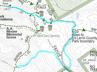
The interesting thing is that I can look back and see exactly why I thought I knew where I was headed. Here's the official map and our route (in blue). I've drawn in the fence line that we walked along and the unmapped road that we joined up with before making the wrong turn.
And here's what I thought was going on:

Again, I've drawn in the fenceline. In this second map, I've redrawn the roads/trails according to where I thought they were layed out. Basically, things were rotated 90 degrees or so from what I thought they were. It's easy to see my mistake in hindsight. But it's easy for me to look back and play over in my head what I was thinking at the time.
Bottom line: check your assumptions using a map and/or compass. My GPS would have done the trick, too (provided I had the foresight to record the waypoints for the peaks and/or trail junctions).
Lesson learned. It did make the trip more exciting. Nothing like not knowing where you are to spice things up.
Hike: 7 miles, 2300' elevation gain
2007 totals: 38 miles, 9400' elevation gain
Not bad for the first month. On a pace for 450 miles, so I should be to 200.7 around Memorial Day.
No comments:
Post a Comment